AIS Vessel Tracker
Overview
The AIS Vessel Tracker plugin displays Automatic Identification System (AIS) positions and detailed information about nearby vessels. The AIS data is received via a network connection from an external AIS receiver.
The plugin can receive NMEA data through a network connection using TCP or UDP. GPS positions received from RMC/GGA NMEA messages can also be used as My location in OsmAnd.
This plugin is a hobby project and is not designed for reliability or accuracy. DO NOT rely on this software for navigation or safety of life.
Required Setup Parameters
To use the AIS Vessel Tracker plugin, you need to enable the plugin and configure a network connection to an external AIS/NMEA data source:
- Enable AIS vessel tracker plugin in the Main Menu → Plugins → AIS vessel tracker.
- Configure the AIS settings
- Configure the connection to your AIS/NMEA data source using TCP or UDP.
- Check that vessels are displayed on the OsmAnd map.
On iOS, you can additionally enable Use NMEA as location source to use GPS positions from RMC/GGA NMEA messages as your current location in OsmAnd.
Vessels on the Map
AIS operates on VHF frequencies (161.975 MHz and 162.025 MHz) and has a limited signal range due to line-of-sight propagation.
Typical AIS reception range:
- 15–20 nautical miles (28–37 km)
- Depends on antenna height, environmental conditions, and obstacles
AIS display on the map:
- Android
- iOS
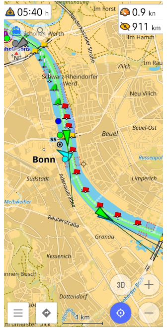
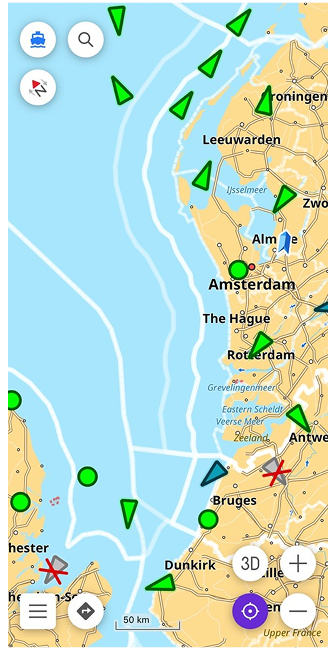
When correctly set up, vessel positions will appear on the map. Key features:
- Vessels move based on real-time speed and course.
- New ships enter and exit the visible area dynamically.
- Tapping a vessel opens detailed information.
AIS Vessel Information
- Android
- iOS
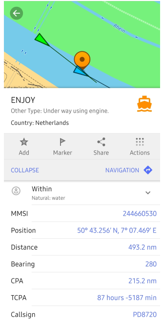
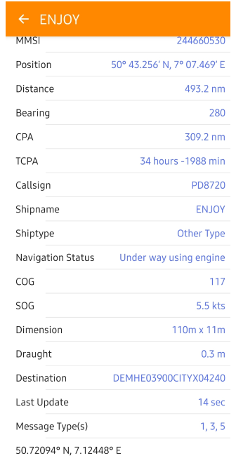
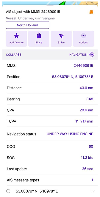
AIS vessels transmit three types of data:
-
Static Information (unchanging data).
Sent every 6 minutes or upon request.- Ship Name (if set)
- MMSI (Maritime Mobile Service Identity) (Unique 9-digit ship identifier)
- IMO Number (if available)
- Call Sign
- Ship Type (e.g., Cargo, Passenger, Fishing Vessel)
- Ship Dimensions (Length and Width)
- AIS Antenna Position (Relative to the ship's hull)
-
Dynamic Information (real-time data).
Sent at different intervals depending on speed and maneuvering.- Ship Coordinates (Latitude & Longitude)
- Course Over Ground (COG)
- Speed Over Ground (SOG)
- Heading (Direction the bow is pointing)
- Ship Status (Underway, Anchored, Maneuvering, etc.)
- Rate of Turn (ROT) (Speed of course change)
- Last Update Time
-
Voyage Information (manually set by crew).
Sent every 6 minutes, manually set by crew- Destination Port
- Estimated Time of Arrival (ETA)
- Draught (Ship's water depth below surface)
- Cargo Type (if transmitted)
- Number of People on Board (optional)
AIS Symbols and Legends
Guidelines for AIS Symbol Presentation
| Symbols | Description |
|---|---|
| Vessel Types Symbols | |
| Green triangle | Cargo ship |
| Blue triangle | Passenger ship |
| Black triangle | Fishing vessel |
| Yellow triangle | Tugboat |
| Red triangle | Tanker |
| White triangle | Military vessel |
| Orange triangle | Special craft (e.g., pilot, icebreaker) |
| Flashing Red triangle | Vessel in distress |
| Navigational Aids Symbols | |
| Green Buoy | Starboard marker (right-hand side of the channel) |
| Red Buoy | Port marker (left-hand side of the channel) |
| Anchor symbol | Anchorage area |
| Ship symbol (SS) | Ferry or passenger terminal |
| Port Crane symbol | Cargo port |
| Black circle | Offshore platform |
| Status Indicators | |
| Solid triangle | Moving vessel |
| Hollow triangle | Anchored or Moored |
| Rotating arrow | Undergoing maneuver |
| Red Flashing icon | Emergency alert |
| Orange Exclamation mark | AIS safety message |
| Route and Speed Indicators | |
| Thin Blue line | Planned route |
| Dotted line | Past track |
| Clock icon | Estimated time of arrival (ETA) |
| Wave icon | Speed over water |
Plugin Settings
- Android
- iOS
Menu → Plugins → AIS vessel tracker → Settings
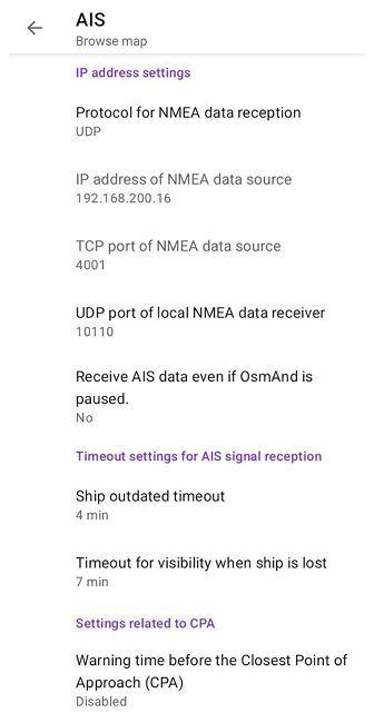
Menu → Plugins → AIS vessel tracker → Settings
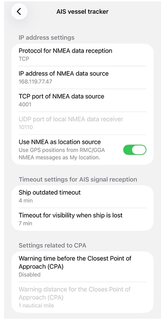
The AIS vessel tracker plugin offers various settings to personalize navigation and interaction for users with disabilities. These settings are applied for all profiles in OsmAnd.
| Setting | Description | Example |
|---|---|---|
| IP address settings | ||
| Protocol | Choose protocol for receiving AIS data | UDP/TCP |
| IP address | Define IP of AIS data source (if TCP is used) | 192.168.200.16 |
| TCP port | Define TCP port number for AIS data | 4001 |
| UDP port | Define UDP port for OsmAnd AIS reception | 10110 |
| Receive AIS data even if OsmAnd is paused (Android only) | Keep the AIS message listener running if OsmAnd is paused or in the background. If disabled, no AIS messages are received when OsmAnd is in the background | Yes/No |
| Use NMEA as location source (iOS only) | Use GPS positions from RMC/GGA NMEA messages as My location | On/Off |
| AIS Signal reception timeout | ||
| Ship outdated timeout | Set timeout for ship outdated visibility: after this time without signal reception, the ship symbol will be crossed out | 2 - 15 min / Disabled |
| Timeout for visibility when ship is lost | Set a timeout for AIS object visibility: If no signal is received within the specified duration, the object will be automatically removed from the display | 3 - 20 min |
| Closest Point of Approach (CPA) Alerts | ||
| CPA Warning Time | Vessel is marked red if time to CPA is below this limit | 1 - 60 min / Disabled |
| CPA Warning Distance | Vessel is marked red if distance to CPA is below this limit | 0.02 - 2 nautical miles |
AIS Simulation Mode
You can simulate AIS vessel positions using OsmAnd Development plugin.
-
Download AIS data text files:
-
Load AIS data into OsmAnd
Open Menu → Plugins → Development → Settings → Simulate vessel traffic and select one of the downloaded files. -
View AIS vessels on the map
Vessel icons will appear based on the simulated data. Tap the vessel icon to view detailed information.