Global Settings
Overview
Global settings are general settings for all profiles in the OsmAnd application. These are the basic settings for the OsmAnd system, and any changes made will affect the entire application.
- Android
- iOS
Go to: Menu → Settings → OsmAnd settings


Go to: Menu → Settings → OsmAnd settings

General
This section contains the basic OsmAnd settings, such as selecting a profile when loading the application, selecting the rendering engine and the folder where the data will be saved.
Default Profile
- Android
- iOS
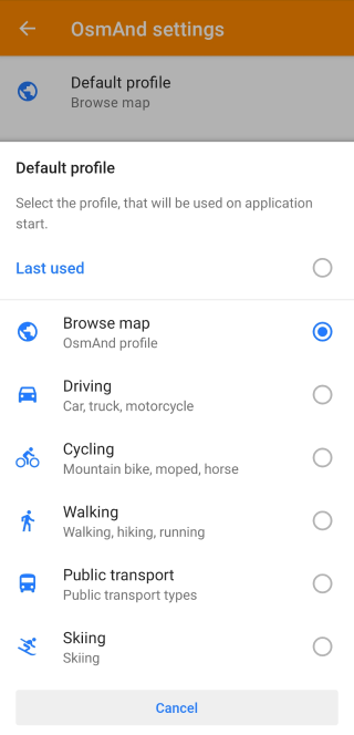
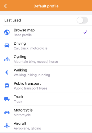
OsmAnd uses the default profile, Browse map, as the first profile for new users, and if this profile has been selected by you, it will be used each time the application is restarted. You can select any profile from the default list, including Last used and Browse map.
- Last used. Allows you to select the profile that was used last.
- Default profile. You select the profile to be used when starting OsmAnd. It can be changed in the application settings.
CarPlay Profile
This feature is available for the iOS version of the OsmAnd app.
Menu → Settings → CarPlay profile

The CarPlay profile is used when connected to your vehicle's CarPlay software and helps you make the most of the optimized version of the OsmAnd app using the audio and video systems to display data on your phone.
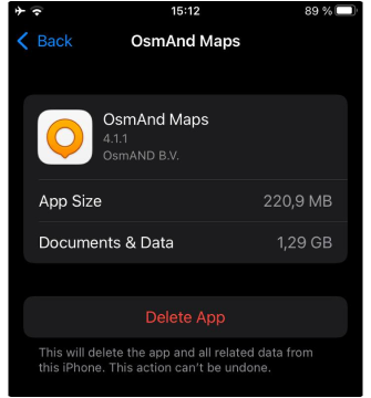
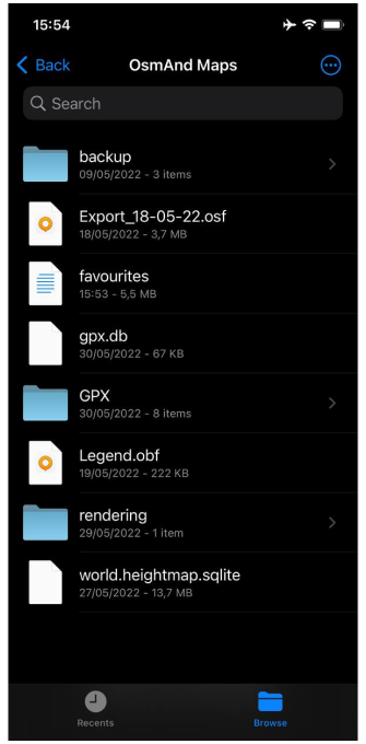
Data Storage Folder
- Android
- iOS
Go to: Menu → Settings → OsmAnd settings → Data storage folder

-
Device memory shows how much free space is left on your device. Tap a field to access the Maps and Resources menu, where you can view and manage detailed information about your OsmAnd data.
-
In the Change storage folder, you can select a folder to save OsmAnd data on your device.
- Internal app memory. Only the OsmAnd app has access to its data and none of the external apps.
- Shared memory. No longer available.
- External storage 1. Only 1 OsmAnd app has access and Admin apps and USB.
- Multiuser storage. Only 1 OsmAnd app has access, but it's shared between multiple Android users.
- Manually specified. Depends on the path.
New storage access guidelines have been implemented in Android versions 11-12. See the Troubleshooting section for details.
Go to: iOS device → Settings → General → iPhone storage → OsmAnd Maps
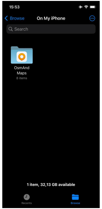
OsmAnd files are visible in the Files application. You can access all OsmAnd files: tracks, favorites, maps, rendering.xml, routing.xmlustom. To do this follow the following path:
Go to: Files → On My Phone → OsmAnd Maps
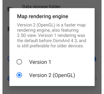
Map Rendering Engine
Menu → Settings → OsmAnd settings → Map rendering engine (Android only)
-
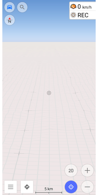
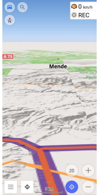
In the Android version of the app, you can switch between Version 1 map rendering, originally implemented in the OsmAnd app, and Version 2, which uses the OpenGL (Open Graphics Library) programming interface for rendering two- and three-dimensional graphical objects.
-
The iOS version uses only OpenGL for map rendering.
| Features | Version 1 | Version 2 (OpenGL) |
|---|---|---|
| Cross-platform | Not used in the iOS version. | Fits both versions. |
| GPU / CPU dependent | Recommended for low-performance or outdated devices. | Powerful rendering engine. Only available for OsmAnd 4.3 and later versions, and in test mode for OsmAnd 4.2. |
| 3D mode | It is possible to view the map in 2D, and you can change the viewing angle to get a 3D view. | You can view the map in 2D and 3D. |
| Map display | The whole map is rendered as a set of tiles, and markers, lines, and text are already inside these tiles. | First, the entire tile pack is rendered, and then the available symbols are applied to the map, layer by layer. |
| Transparent symbols overlay / underlay | Supports all settings. | It does not support a raster layer on top of vector text. |
| 3D Terrain | Not supported. | This feature visualizes the terrain on the map by adding elevation information to a normal 2D map, which creates a 3D and depth effect. |
| 3D Tracks | Not supported. | This feature allows you to display tracks by altitude above sea level. |
| Online map | It does not support the display of Contour lines if the map source is any online tile map. | When the map source is an online map, 3D maps are also used, and the display of Contour lines on the map is supported. |
| Weather plugin | You cannot use this plugin. | Convenient to use with the plugin. |
| Globe View | Not supported. | Allows displaying the map as a spherical Earth (globe) instead of a flat projection. |
The image for the 3D view of the map is loaded tile by tile, then all the symbols. The rendering speed of the map depends on the number of 2D and 3D graphical objects on it, and directly on the performance of your hardware. Therefore, Version 2 (OpenGL) cannot be used on low-performance devices.
 |  |  |
Privacy and Security
OsmAnd allows you to choose whether to share your in-app activity and identifiers (Android only) in the app, the ability to edit your history and use a proxy (Android only) of your choice.
More information can be found in OsmAnd Privacy and Security Policy
Analytics
- Android
- iOS
Go to: Menu → Settings → OsmAnd settings → Analytics
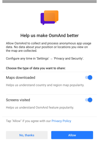
Go to: Menu → Settings → OsmAnd settings → Send anonymous data
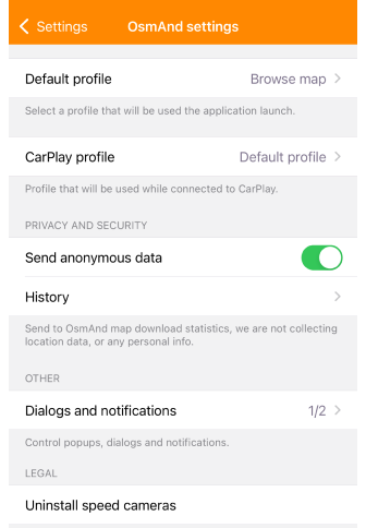
Analytics (Android) or Send anonymous data (iOS) setting allows you the choice whether to provide anonymous data about Downloaded Maps and Visited Screens (Android).
Data about your location or the places you view on the map is not collected.
Identifiers
This feature is currently not available for the iOS version of the OsmAnd app.
Menu → Settings → OsmAnd settings → Privacy and security → Identifiers
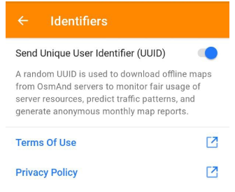
A UUID (Unique User Identifier) is generated for each installation of the OsmAnd application and sent to the servers during map loading.
- A random UUID is used to download offline maps from OsmAnd servers to control the rational use of server resources, predict traffic usage, and provide general monthly reports on map downloads.
- The UUID changes every 3 months.
- Starting with OsmAnd version 4.3, you can disable the collection of user data when using the OsmAnd app. Then the UUID will not be sent with any download request.
- You can read more information in the Terms of Use (ToS).
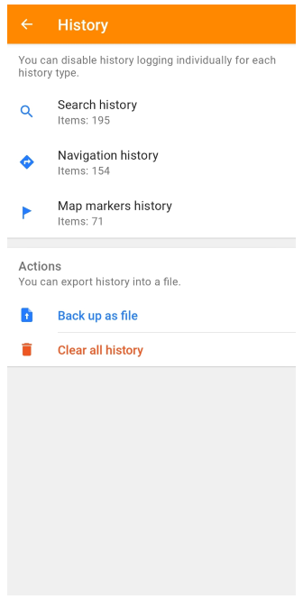
History
- Android
- iOS
Go to: Menu → Settings → OsmAnd settings → History
Go to: Menu → Settings → OsmAnd settings → History
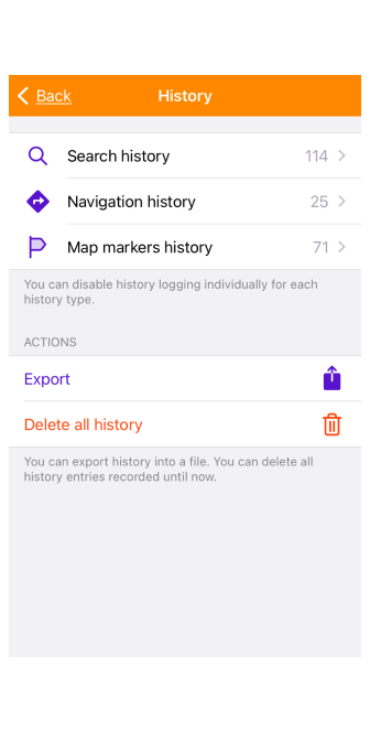
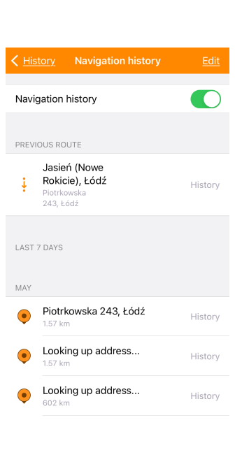
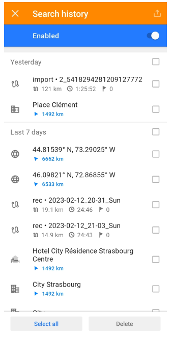
The application records the history of previously entered data (history) in the following categories: Search, Navigation, Map markers. Using the switch on the appropriate tab, you can Enable / Disable logging for certain categories of entries. You can also manage (view, delete, and share) previously recorded data.
- Backup as file (Android) or Export (iOS) is used to make a backup file of your history.
- Clear all history (Android) or Delete all history (iOS) is used to delete all history entries recorded up to the time of deletion.
Share and delete history.
- Android
- iOS
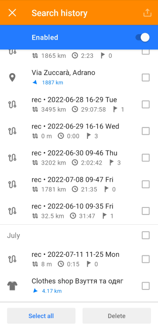
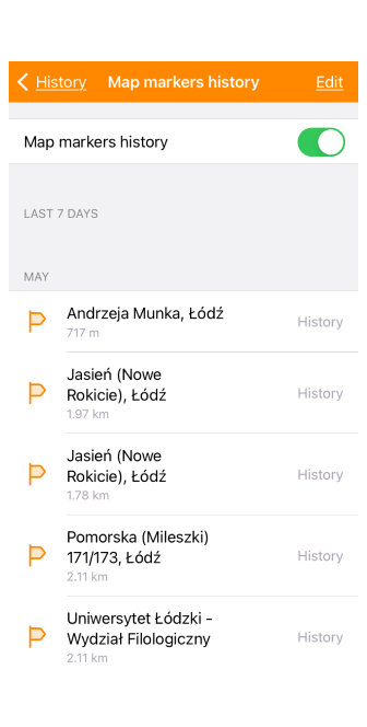
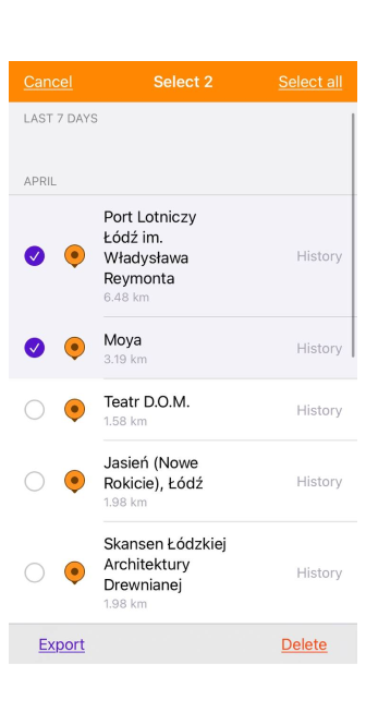
- You can delete one or more items from the history list or share them as a file (to access these functions in iOS, tap the Edit button).
- To delete or export multiple records simultaneously, select checkboxes next to the required records and tap the Export or Delete buttons.
Proxy
This feature is currently not available for the iOS version of the OsmAnd app.
Menu → Settings → OsmAnd settings → Proxy
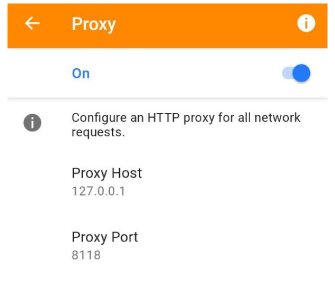
Proxy setting allows you to configure an HTTP proxy for all network requests. You can set the Proxy Host and Proxy Port.
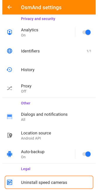
Other
In this section of the OsmAnd settings, you can configure the notifications you receive, the location service, and how your application settings are saved.
Dialogs and notifications
- Android
- iOS
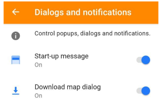

The Dialogs and notifications setting allows you to enable/disable pop-ups, dialogues, and notifications.
- Start-up message includes promotions, quizzes, events, and more.
- Do not show promotions (iOS) suppresses displaying app discounts and special local event messages.
- Download map dialog informs you that specific maps can be downloaded.
Location Source
Menu → Settings → OsmAnd settings → Location source (Android only)
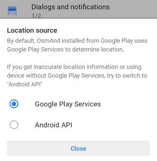
OsmAnd provides you with a choice of services to determine your location. It is recommended that you read more information about Location permission and Troubleshooting for this section.
Android:
- You can choose which Google Play or Android API services OsmAnd will use to determine your location. This can be useful for devices without Google Play Services or in case of inaccurate location or altitude data when recording tracks.
- OsmAnd receives data from the resources Google Fused Location Providers and Android GPS and Network Providers. You can switch Location source in: Menu → Settings → OsmAnd settings → Location source.
iOS:
- The iOS system uses the iOS API to determine location.
- All settings for OsmAnd Location can be found in iOS device settings: Settings → OsmAnd maps → Location
- Privacy of Location services: Settings → Privacy → Location Services
Auto-Backup
This feature is currently not available for the iOS version of the OsmAnd app.

-
Android or OsmAnd Cloud can save your data and app settings.
-
By default, your OsmAnd settings and Favorites map markers are automatically backed up by the Android system. This allows you to restore them on new devices or after reinstalling the app.
-
Please note that the backup size is restricted to 25MB.
-
To find the backup files, use a third-party file manager app.
NOTE: You can find the backup files using the Android file manager: Android → data → net.osmand → files → backup, but be aware that in recent versions of Android, access to system directories is limited.
If you are using OsmAnd Cloud, it's recommended to deactivate this default backup option to prevent any confusion during reinstallation.
Legal
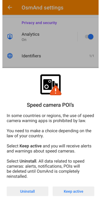
OsmAnd can warn you about speed cameras, but only if the laws in your country permit it.
Uninstall Speed Cameras
- Android
- iOS
Go to: Menu → Settings → OsmAnd settings → Legal → Uninstall speed cameras
Go to: Menu → Settings → OsmAnd settings → Legal → Uninstall speed cameras
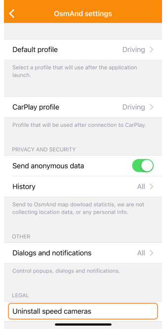
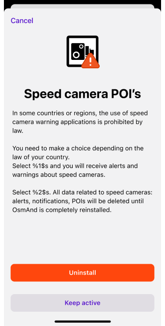
This setting allows you to activate or deactivate POI with speed cameras, you need to restart the OsmAnd application to make changes.
In some countries or regions, using speed camera warning applications is illegal. You must make a choice depending on the laws in your country. Select Keep active, and you will receive speed camera alerts and notifications. Select Uninstall and all data related to speed cameras, such as warnings, notifications, and POI, will be deleted until you completely reinstall OsmAnd.
Read about alerts for speed cameras on your route in the article Navigation widgets in the Alert widget section.
Related Articles
Troubleshooting
-
Android 12+ (change storage folder). New storage access guidelines have been implemented in Android versions 11-12. These changes particularly affect the storage of maps on SD cards, resulting in significantly slower file access performance and stricter access limitations to SD card folders on Android 11 and 12. For how to solve this problem, see the Troubleshooting section.
-
Location source for altitude issues. Google Play has changed its policy, and to comply, OsmAnd, starting with version 3.9, must use Google Play Services to get location fixes while running in the background. Read more information in Troubleshooting section.