About OsmAnd routing
Overview
Offline OsmAnd routing is based on OpenStreetMap data and provides variety of routes for different purposes. This is a list of predefined routing types which could be extended. The navigation rules are contained in routing.xml file and are used for offline routing. The route type changes automatically, when you change your profile.
Routing Types
The following profiles with their routing types are preset in OsmAnd: Driving, Cycling, Walking, Truck, Motorcycle, Moped, Public transport, Boat, Aircraft, Skiing, Train, Horseback riding. Besides these, you can create your own profiles with specific routing rules or modify OsmAnd routing algorithm.
-
Truck, Motorcycle, Moped, Train, Aircraft, Boat and Horseback riding profiles are switched off by default. To use these profiles, you need to activate them in Menu → Settings → App profiles.
-
Direct-to-point navigation type doesn't have its own profile and can be used with any enabled one.
-
OsmAnd offline routing can be configured by modifying the .xml file. For more information, see the Customize offline routing article.
| Category | Description | Note |
|---|---|---|
| OsmAnd offline routing | OsmAnd offline routing mechanism uses predownloaded maps as data source for route calculation. | Navigation types: Boat, Bicycle, Car, Horseback riding, Moped, Motorcycle, On foot, Public transport, Ski, Truck, Train. |
| Direct to point routing | Also uses offline maps and provides a straight line routing (or point-to-point navigation). | Navigation types: Straight line, Direct-to-point. |
| BRouter (offline) | Offline routing provided by BRouter app. | Available for Android only. The full description read here. |
| Online (Android) | Online routing builds the route servers' resources online by the Internet connection. | Available for Android only. You can configure online routing to build a route from various online routing engines such as Graphhopper, OSRM, Routing OSM DE, Generic GPX. |
- Car routing (Truck, Motorcycle) - OsmAnd provides driving instructions for drivers of Cars, Trucks and Motorcycles.
- Bicycle routing (MTB) - Bicycle routing provides navigation prompts specifically for cyclists and mtb enthusiasts. It can also be used by moped (scooter) drivers.
- Pedestrian routing - can be used not only for walking around the city, but also during hiking trips.
- Moped routing - is based on the bicycle routing, though it has it's own features.
- Public Transport routing - can help you while traveling around the city.
- Horseback routing - provides equestrians with tools they need to plan and enjoy their horseback riding activities.
- Skiing routing - allows users to plan and navigate ski tours and other winter sports activities using the OsmAnd mobile app.
- Train routing - provides an opportunity to use the railroad tracks for navigation.
- Boat routing - can be used to build a route on rivers, channels, small lakes and in the open sea but only when fairways are marked in OpenStreetMap.
- Straight line routing - provides a straight line routing (or "point-to-point" navigation) that is recalculated when your location changes.
- Direct-to-point routing - provides a straight line routing (or "point-to-point" navigation) which stays stable for whole navigation in contrast to Straight line routing (route recalculation is disabled).
Customize Offline Routing
You can also create your own routing.xml file or modify default routing.xml and use it for navigation (only for advanced OsmAnd users).
- Copy the routing.xml file to your device. Read the Help information carefully. As an example, view the routing.xml file of the OsmAnd user.
- After making the changes, the new routing.xml file can be added to OsmAnd by tapping it and selecting to open it in the OsmAnd app.
- Select the modified Navigation type for your profile.
More information about this feature can be found in the Technical documentation and on OsmAnd's GitHub page.
Avoid Specific Roads
Avoid roads feature is global and affects all Routing types except Online routing and BRouter.
There are two possible ways to choose which roads to avoid when calculating a route:
- Select road type in the Route parameters section of Navigation settings. Description of this setting is provided in the articles about Routing types settings. As example, see Car / Truck / Motorcycle routing type description.
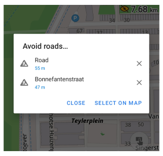
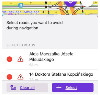
- You can also select specific roads that will not be used for routing using the Avoid roads option through the map context menu or using Avoid roads menu (Menu → Navigation → Avoid roads…).
When a road type (such as Unpaved roads) is selected in the Avoid settings, OsmAnd strictly excludes such roads from route calculation. Even very short sections (for example, 100–200 meters of unpaved road) are completely avoided and will not be included in the route under any circumstances. As a result, routes may become significantly longer if avoiding such roads requires detours.
If the Avoid option is disabled, these roads are still allowed but may be assigned lower priority (penalty), meaning OsmAnd will prefer better roads when possible but can still include them if needed.
- The road must be marked at maximum zoom, as OsmAnd may misinterpret the tap and block, for example, the incorrect side of two-roadways road or sidewalk.
- The Avoid specific roads function incorrectly works with Navigation by track option and doesn't impact simplified Markers navigation.
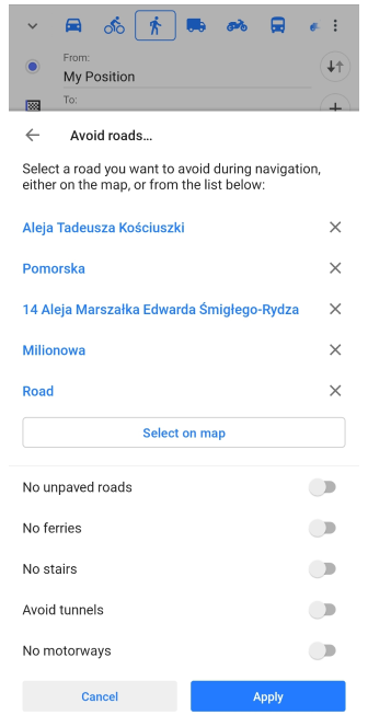
Avoid Roads Menu
- Android
- iOS
Go to: Navigation button → Settings → Avoid roads...
Go to: Navigation button → Settings → Avoid roads
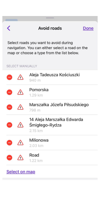
In this menu, you can cancel the previous selection of the road that should be avoided. To do so, tap a cross (Android) or a red "-" opposite the road you intend to use for route calculation.
Using Select on map option you can continue to mark roads as invalid for routing on the OsmAnd map.
When you select a road to avoid using map context menu or Avoid roads menu, the list of roads will be shown above map screen.
- Android
- iOS
Export / Import
- Android
- iOS
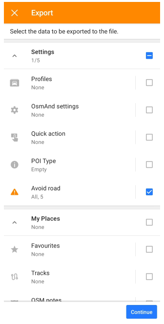
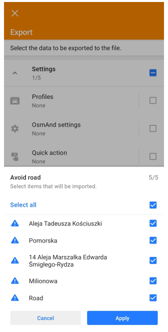
Go to: Menu → Settings → Actions → Export
Go to: Menu → Settings → Actions → Export
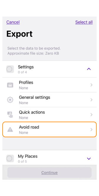
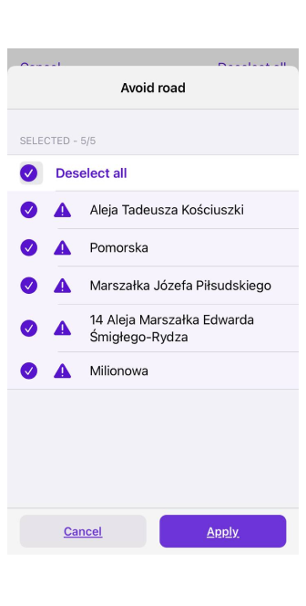
Depending on your device settings and available applications, your whole list of roads to avoid or just one of them can be exported as an .osf file to a different locations. Select the roads you want to export in the suggested list.
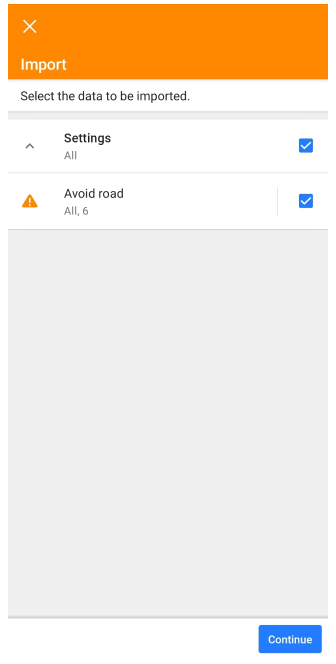
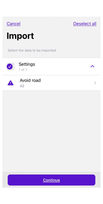
You can import roads to avoid during route calculation from other sources in .osf file format. Also, it can be done using Import option (Menu → Settings → Actions → Import). You can choose to import all data or only few roads to avoid (marking a road with a tick in the list).
- Android
- iOS
The most convenient way to synchronize roads to avoid between your devices is to use OsmAnd Cloud (Pro subscription required).
Consider Temporary Limitations
Menu → Settings → App profiles → Navigation settings → Route parameters
Consider temporary limitations option allows taking into account temporary road restrictions when calculating routes. They may include things like road construction or road closures for some reason (an accident, road repairs, natural disasters). Enabling this option can help you avoid unexpected detours or delays. Please note that sometimes this information may be outdated.
In OpenStreetMap, this information is usually marked with the tag temporary.
Development Section
The Development section of the Route parameters settings (Menu → Settings → app profile → Navigation settings → Route parameters → Development) is visible only when OsmAnd development plugin is enabled. It includes settings such as Routing type (Android) / Routing algorithm (iOS), GPX approximation (Android only), Autozoom, and Live updates data (Android only). Read the Navigation Settings article for a detailed description.