Profiles (Settings)
Overview
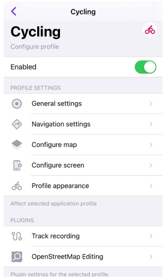
OsmAnd offers a variety of default profiles tailored for different activities, including driving, cycling, walking, and more specialized activities like skiing and boating. These profiles are designed to enhance your navigation experience according to the activity you are engaged in. Each profile includes configurable options, enabling you to adjust settings and incorporate additional plugins to match your preferences.
-
Certain profiles, such as Skiing and Boat, have additional features that become available only when the corresponding plugins are enabled.
- Plugins can be activated by navigating to Menu → Plugins → Ski map view or Nautical map view.
- Enabling the plugins provides the profiles with the essential features to meet the specific requirements of these activities.
-
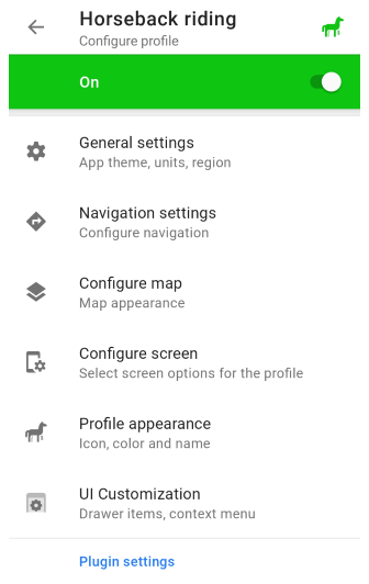
It's important to note that some profiles, such as Truck, Motorcycle, Moped, Train, Aircraft, Boat, and Horseback riding, are not activated by default.
- To access and use these profiles, you need to manually enable them in Menu → Settings → App profiles.
- This method helps maintain an organized and relevant list of profiles by activating only those required for specific activities.
- Android
- iOS
- Menu → Configure profile (Browse map or any other profile)
- Menu → Settings → App profiles
Go to: Menu → Settings → App profiles
Profile Configuration
All settings apply exclusively to the currently selected application profile.
- Android
- iOS
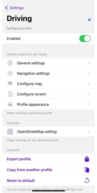
This section contains all settings related to appearance, navigation options, map display, settings menu, and profile screen.
Free Cloud Backup
- Android
- iOS
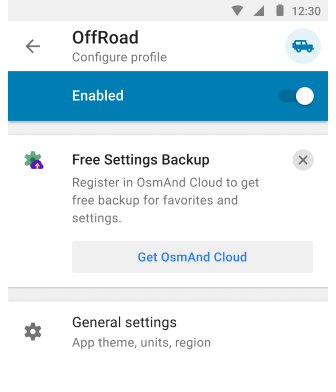
Go to: Menu → Configure profile
Go to: Menu → Settings → App profiles
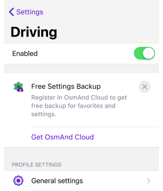
OsmAnd allows you to back up your application profile settings to OsmAnd Cloud, ensuring that your configurations are securely stored and easily restored across Android, iOS, and Web versions. This backup feature protects your settings in case of device failure or app reinstallation. You can benefit from this special plan using OsmAnd Start.
You must have an OsmAnd Cloud account to use the Free Settings Backup. If you have an OsmAnd Pro subscription or an active OsmAnd Cloud account, the promotion banner will not be displayed.
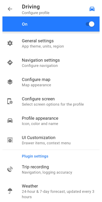
General Settings
This section contains settings for the application theme and compass button, map and profile data units and formats, external input devices, and many other settings to create the optimal configuration for your chosen profile.
Appearance
- Android
- iOS
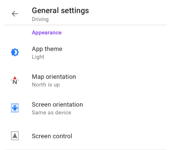
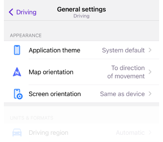
Go to: Menu → Configure profile → General settings → Appearance
Go to: Menu → Settings → App profiles → General settings → Appearance
-
App theme. Allows you to set a day and night theme for the app, which can be applied to one profile or all at once. This option does not change the map mode settings.
- Dark theme
- Light theme
- System default
Applies the system theme. By default, and for all new users, the map style corresponds to the light or dark theme selected in your device's system settings.
-
Map orientation. Allows you to choose the map orientation mode for the selected profile.
- Manually rotated
- Movement direction
- Compass direction
- North is up
-
Screen orientation. Sets and locks the screen position in the OsmAnd application. This feature is not supported on iPad.
- Portrait
- Portrait (inverted)
- Landscape
- Landscape (inverted)
- Same as device
-
Screen control (Android only). Opens the screen control menu, where you can select options for the device screen while navigating to save device battery consumption.
Units & Formats
- Android
- iOS
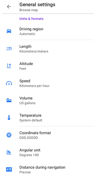
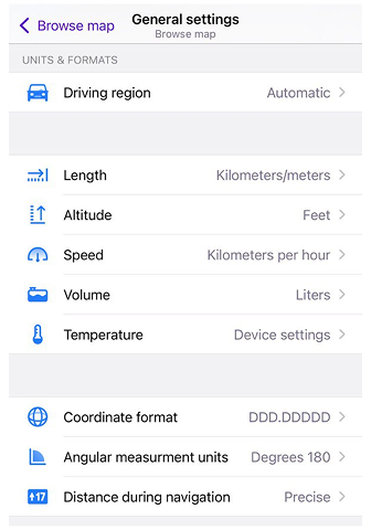
In the Units and Formats section, you can adjust measurement units and formats to align with your personal preferences and regional standards, ensuring all data is displayed conveniently and familiarly.
| Driving region | Automatic |
|
| Europe, Asia, Latin America, and similar |
| |
| United States |
| |
| Canada |
| |
| UK and similar |
| |
| Japan |
| |
| India |
| |
| Australia |
| |
| Length | Kilometers/meters | 1 km / 1000 m |
| Miles/feet | 0.62 ml / 3281 ft (1000 m) | |
| Miles/meters | 0.62 ml / 1000 m | |
| Miles/yards | 1094 ya / 0.62 ml (1000 m) | |
| Nautical miles/feet, Nautical miles/meters | 0.54 nmi / 3280.84 ft / 1000 m Length applies to horizontal distance values (e.g., driving/route distances and maneuver distances in navigation). | |
| Altitude |
| 1 m / 3.28 ft Altitude applies to altitude/elevation values and related metrics (uphill/downhill, altitude range) in Altitude widgets, Navigation route info, Track statistics, and mountain peak elevation labels on the map. By default, Altitude is synced with Length and becomes independent only after the user manually changes it. |
| Coordinate format | DD°MM.MMMM′ | Example: 50.12333° 19.93233° (Lat Long) |
| DD°MM.MMM′ | Example: 50°7.393′ 19°55.941′ (Lat Long) | |
| DD°MM′SS″ | Example: 50°7′23.6″ 19°55′56.4″ (Lat Long) 23°27′30″ | |
| UTM Standard | 34N 5552876 423678 (Zone Northing Easting) . OsmAnd uses the UTM Standard, which is similar but not identical to the UTM NATO format. | |
| MGRS | Example: 34U DA 23678 52873 . OsmAnd uses MGRS, which is similar to the UTM NATO format. | |
| Open Location Code | Example: 9F2X4WFJ+7W (Open Location Code represents area 9m x 14m) | |
| Swiss Grid (CH1903) (Android version only) | Example: 2 215 227.87, 830 915.9 (Swiss coordinate system) | |
| Swiss Grid (CH1903+) (Android version only) | Example: 4 215 227.87, 1 830 915.9 (Swiss coordinate system) | |
| Angular unit (Android) / Angular measurement units (iOS) | Degrees 180° | All angular values have readings from 0° to 180° and from 0° to -180°. |
| Degrees 360° | All angular values have readings from 0° to 360°. | |
| Milliradians | All angular values have milliradian value. | |
| Speed | Kilometers per hour | 90 km/h |
| Miles per hour | 55.92 mph | |
| Meters per second | 25 m/s | |
| Minutes per mile | 1.073 min/m | |
| Minutes per kilometer | 0.667 min/km | |
| Nautical miles per hour (knots) | 48.59 kn | |
| Volume | Liters | Europe, Aisa, Latin America, Canada, Japan, India, Australia |
| Imperial gallons | UK and similar | |
| US gallons | United States | |
| Temperature | System default | |
| Celsius | ||
| Fahrenheit | ||
| Distance during navigation | Precise | For precise measurements, choose how distance information is displayed in the navigation widgets, such as the distance to a point, the next turn, or a specific lane. |
| Round up | For better readability, the numbers displayed in the navigation widgets (distance to a point, next turn, or lane) will be rounded down to have fewer digits. For examples: 3672 m → 3.6 km, 462 m → 400 m, 184 m → 150 m, 47 m → 40 m, 18 m → 15 m. |
Other
- Android
- iOS
Go to: Menu → Configure profile → General settings → Other
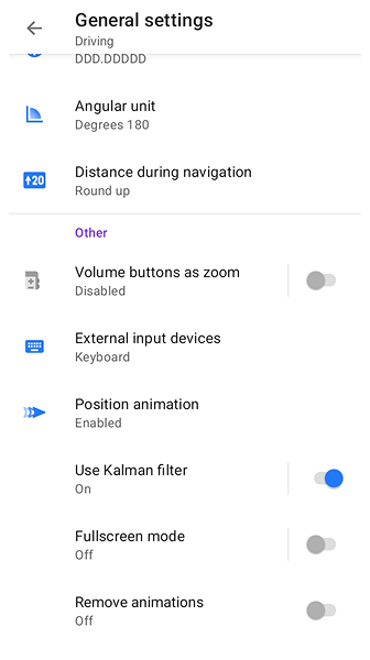
Go to: Menu → Settings → App profiles → General settings → Others
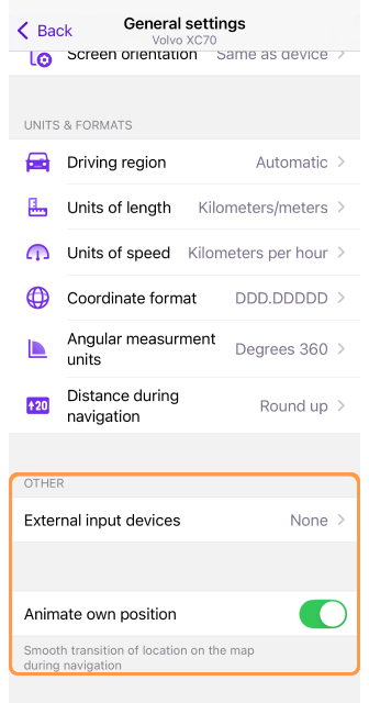
The Other section provides additional profile settings to customize OsmAnd’s interface and input controls. These settings allow you to configure external devices, adjust animation preferences, and toggle fullscreen mode.
-
External input devices – Connect external controllers such as WunderLINQ, Keyboard, or Parrot to operate OsmAnd using physical buttons.
-
Position animation / Animate own position – The position icon animates with each GPS point received (once per second). A slight delay in its movement may be noticeable, especially during fast movement or GPS signal fluctuations. You can adjust this effect using the Prediction time setting (Android only): higher values increase smoothness but add delay, lower values reduce delay but may make movement less smooth.
-
Volume buttons as zoom (Android only) – Enable or disable the ability to use your device’s volume buttons for zooming in and out on the map.
-
Use Kalman filter (Android only) – Smooths map rotation with gradual movement, reducing sudden position shifts. This introduces a small delay (less than 1 second).
-
Fullscreen mode (Android only) – Tap an empty space on the map to hide control buttons and widgets, maximizing map visibility.
-
Remove animations (Android only) – Disable animations in navigation mode for faster screen transitions.
Navigation Settings
- Android
- iOS
Go to: Menu → Configure profile → Navigation settings
Go to: Menu → Settings → App profiles → Navigation settings
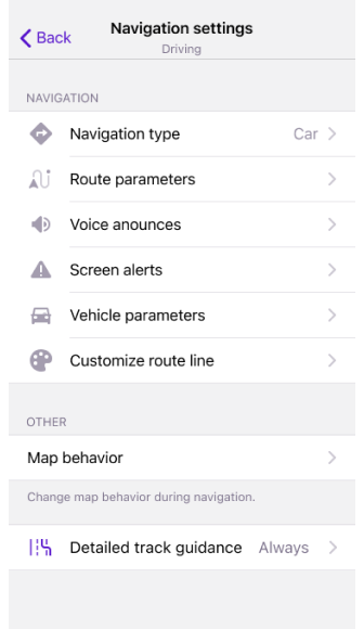
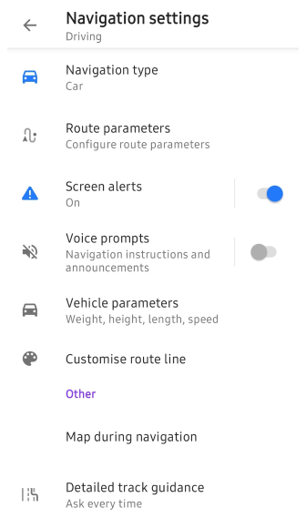
For a detailed overview of navigation options, refer to the Navigation Settings article, which explains how to configure OsmAnd for an optimal navigation experience.
-
Navigation type - Choose the appropriate navigation mode based on your travel method and internet availability.
-
Route parameters - Define how OsmAnd calculates routes, including preferences for avoiding certain roads or selecting route types.
-
Screen alerts - Enable the Alerts Widget to display real-time notifications for speed limits, turns, and other important road conditions.
-
Voice prompts - Enable audio guidance to receive spoken navigation instructions while driving or walking along a selected route.
-
Vehicle parameters – Configure vehicle-specific settings such as maximum speed and vehicle height to ensure accurate routing and avoid restricted roads.
-
Customize route line – Adjust the color, width, and style of the route line displayed on the map for better visibility during navigation.
-
Map during navigation – View real-time positioning on the map, track progress along the route, and improve orientation using landmarks.
-
Detailed track guidance – Improve turn-by-turn navigation by aligning your route with mapped roads. Available settings: Ask Every Time or Always.
There are no navigation settings in the Browse map profile.
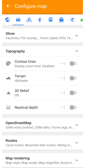
Configure Map
- Android
- iOS
- Menu → Configure profile → Configure map
- Menu → Settings → App profiles → Configure map
Go to: Menu → Settings → App profiles → Configure map
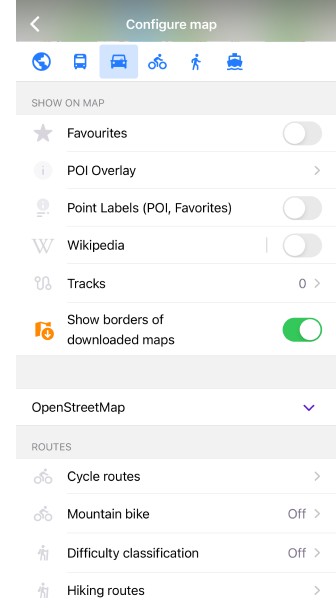
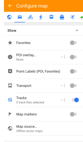
The Configure map menu allows you to customize the map display settings for the selected profile, enabling better visualization of key map elements.
With this menu, you can:
-
Highlight important map elements, including Favorite points, Navigation markers, or special Points of Interests on the map.
-
Display specific routes and GPX files, including third-party tracks for navigation or analysis.
-
Overlay additional map layers, such as terrain information, satellite imagery, or other available raster maps.
-
Enable public transport visualization, showing routes and stops for better trip planning.
-
Adjust map appearance by selecting a different map style to match your needs.
Configure Screen
- Android
- iOS
- Go to: Menu → Configure screen
- Go to: Menu → Settings → App Profile → Configure screen
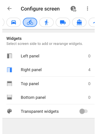
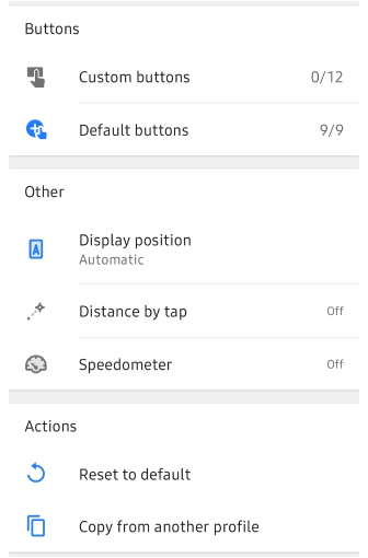
Go to: Menu → Configure screen
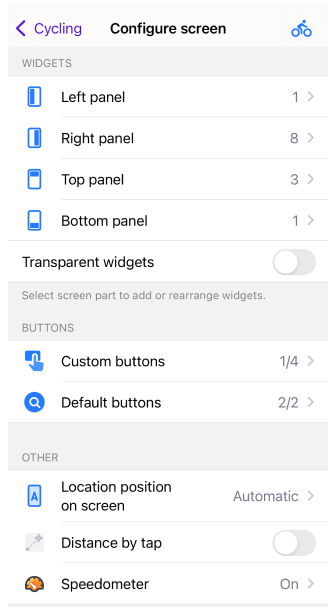
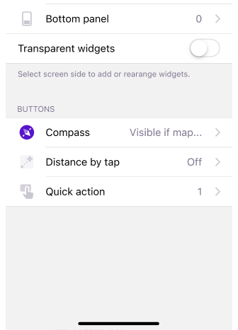
The Configure screen is a menu that allows you to configure the widgets for the selected profile to be displayed on the map. On this screen, you can enable and configure Informational and Navigational widgets, as well as other items.
Profile Appearance
- Android
- iOS
Go to: Menu → Configure profile → Profile appearance
Go to: Menu → Settings → App profiles → Profile appearance

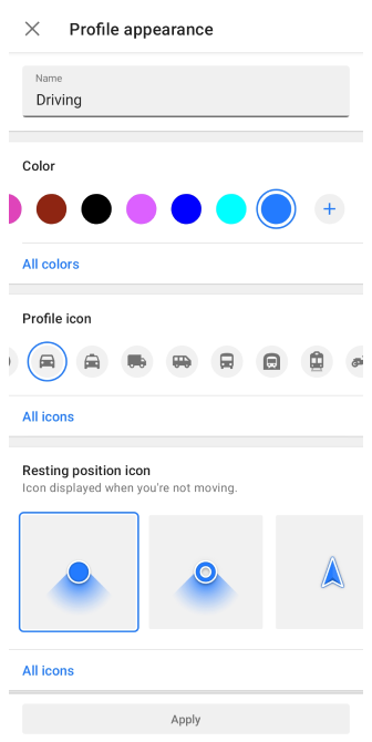
The Profile appearance settings allow you to customize your profile's name and visual representation. You can also modify the appearance of My Location here. While the profile name must be unique, icons and colors can be the same across different profiles. These changes will be applied across various parts of the application, such as the Route preparation menu.
My Location Appearance
- Android
- iOS
Go to: Menu → Configure profile → Profile appearance
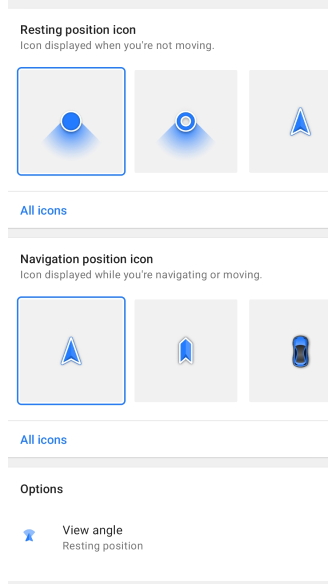
The My Location appearance settings allow you to customize how your location is displayed on the map, both when stationary (Resting) and in motion (Navigation). Motion is detected by the operating system when the device speed is greater than zero.
Go to: Menu → Settings → App profiles → Profile appearance
The My Location appearance settings allow you to customize how your location is displayed on the map, both when stationary (Resting) and in motion (Navigation). Motion is detected by the operating system when the device speed is greater than zero.
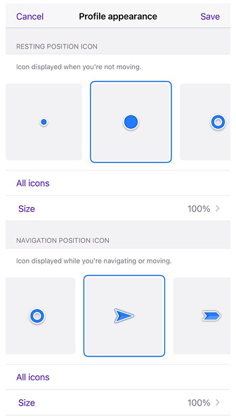
Use Icon size to adjust the size of the My Location position icon independently from the app’s text size. You can set different sizes for Resting and Navigation modes. The size can be adjusted from 50% to 300% (50, 75, 100, 125, 150, 200, 250, 300%). The default value is 100%. Tap Icon size to open the size settings, then use the slider or the + / – step buttons to change the value. Use Reset to default to return to 100%.
View Angle and Location Radius
You can customize the visual elements related to your location and apply them separately or together for Resting and Navigation positions. For both 2D and 3D modes, View Angle and Location Radius are displayed in the same color selected for the navigation profile, directly below the My position icon.
- View angle – Displays a cone-shaped area indicating the direction you are currently facing.
- Location radius – Shows a circular area around your icon, representing the accuracy of your current location.
Custom 3D Icons
For a more personalized experience, you can create and add custom 3D icons to OsmAnd.
How to add a custom 3D location icon:
-
Create a 3D model. Design your icon in MTL and OBJ formats.
-
Integrate the model into OsmAnd:
-
Develop a custom plugin using the provided plugin example.
-
Place your 3D icon files in the following paths:
..osmand/models/icon_folder_name/custom_3d_file.mtl
..osmand/models/icon_folder_name/custom_3d_file.obj -
Alternatively, copy the MTL and OBJ files directly into the OsmAnd folder using the same directory structure.
-
Map Orientation Modes
You can control how the My Location icon behaves using different map orientation modes.
- If the location icon jiggles or rotates while stationary, switch from Movement Direction Mode (Rotate Map by Bearing) to another mode.
- Adjust additional settings in Menu → Settings → App Profiles → Profile Appearance → Options.
- Learn more about bearing and direction tracking in the Bearing Widget section.
UI Customization
This feature is currently not available for the iOS version of the OsmAnd app.
To hide all control parameters of unused plugins, disable them.
Menu → Settings → App profiles → UI Customization
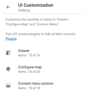
With the UI customization feature, you can adjust the number of items in actions such as Drawer, Configure map and Context menu actions. Information about the number of added items out of all possible items can be found under the title of each feature.
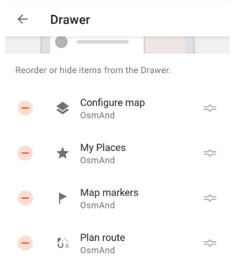
Drawer
-
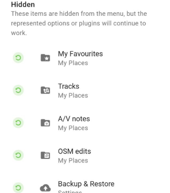
Main visible items - In the Customize UI section, you can reorder hide, and restore items from the Drawer to match your preferences.
-
Reset to default - Restores the original list of items in the drawer, instantly undoing any customizations.
-
Copy from another profile - Allow you to copy the drawer layout from another OsmAnd profile to maintain a consistent setup across profiles.
Configuring the Map
-
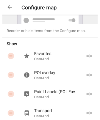
Configure map menu - In the Customize UI section, you can reorder or hide items from the Configure map, allowing quick access to frequently used settings.
-
Reset to default - Restores the original item list in the Configure map menu, removing any changes.
-
Copy from another profile - Copies the Configure map menu layout from another OsmAnd profile.
Context Menu Actions
-
Map context menu - In the Customize UI section, you can reorder or hide items in the map context menu to optimize access to frequently used features.
-
Reset to default – Restores the default item list in the map context menu, instantly reverting any modifications.
-
Copy from another profile – Copies the context menu arrangement from another OsmAnd profile to maintain consistency across different profiles.
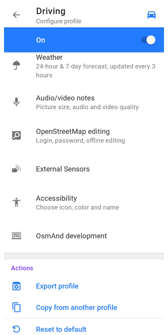
Plugin Settings
To access the plugin's settings, you must first enable the plugin in the Plugin section of the main menu.
- Android
- iOS
Go to: Menu → Settings → App profiles → Plugins

Go to: Menu → Settings → App profiles → Plugins

Plugins unlock additional features of the application and can be either paid or free. Some plugins have their own settings, others do not. OsmAnd gives you the possibility to configure plugins for each profile separately.
-
Trip Recording. This item opens the trip recording settings for the selected profile, where you can choose any parameters for recording your journeys.
-
Weather. Interactive Weather map layers allow you to monitor the temperature, air pressure, cloud coverage, wind speed, and precipitation in your city or any other location on a global map.
-
Audio / Video Notes (Android only). This item opens audio-video plugin settings for the selected profile. The Audio/Video Notes plugin extends the functionality of OsmAnd by allowing you to create your notes in various formats such as photo, video, or audio and associate them with geographical location or current location.
-
OpenStreetMap Editing. This item opens the OpenStreetMap editing plugin settings for the selected profile. With OsmAnd and the OSM editing plugin, you can contribute to OpenStreetMap.org by creating or modifying POIs, adding or commenting on notes, and uploading recorded GPX tracks.
-
External Sensors. When you tap an item in the Plugin Settings section, the settings of external sensors for the selected profile are opened. The External Sensors plugin allows you to read and record data from wireless external sensors and display it using widgets in the OsmAnd application.
-
Accessibility (Android only). This item opens Accessibility plugin settings for the selected profile. The Accessibility plugin settings allow you to customize the application according to your needs. All settings relate to the navigation process and are set individually for each profile.
-
OsmAnd Development. This menu opens the OsmAnd development plugin settings, where you can configure the OsmAnd application for testing purposes or explore upcoming features. These settings are intended for developers and are not required for normal use of the application.
Changing the settings of the OsmAnd development plugin affects all profiles.
-
Wikipedia (iOS only). This menu opens Wikipedia plugin settings. You can select the language in which articles will be displayed and choose whether to download images from Wikipedia. Having Wikipedia on your trip enhances your experience by providing information about the places you visit. It works offline and displays relevant Wikipedia articles directly on the map related to points of interest.
-
Vehicle Metrics. This menu opens Vehicle metrics plugin settings. It allows you to connect OBD-II scanner to OsmAnd.
-
AIS vessel tracker (Android only). This menu opens AIS vessel tracker plugin settings. This plugin allows you to connect AIS tracker to OsmAnd.
Actions
- Android
- iOS
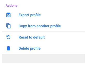
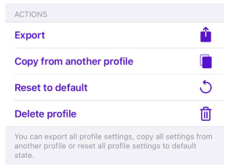
Actions with selected profile:
-
Export profile - Export all settings of the selected profile in OSF format.
-
Copy from another profile - Copies all settings from another existing profile in your OsmAnd application.
-
Reset to default - Returns all settings to the initial state.
-
Delete profile:
- This action is available only for Android and only for a Custom profile.
- Default profiles cannot be deleted.
- To add a profile, go to Menu → Settings → App profiles → + New profile.