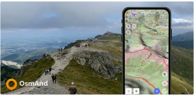
Terrain on the map

Hi Everybody!
OsmAnd has the ability to display terrain offline in a variety of ways: contour lines, hillshades, slopes, altitude graphs..
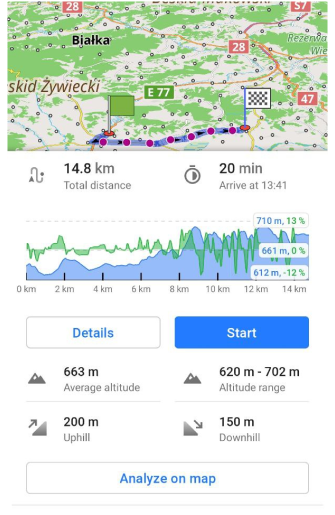
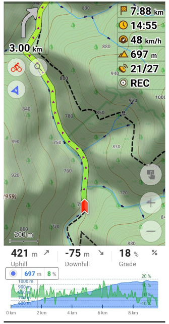
In the last releases for Android, we added Pro features with Elevation data. The Elevation widget shows a graph with the elevation and slope of your navigation route and your current location on this graph with the current altitude and slope. The graph is plotted on two axes. The X-axis is the distance of your route. The Y-axis is the altitude above sea level, the value of which depends on the relief, and the slope is displayed as a percentage.
The relief of the terrain has a great influence on the trip. Of course, it's very important to know what uphills and downhills await us on the way. In OsmAnd you can see the Altitude graph when building a route. The graphs can be worked with both GPX tracks and routes.
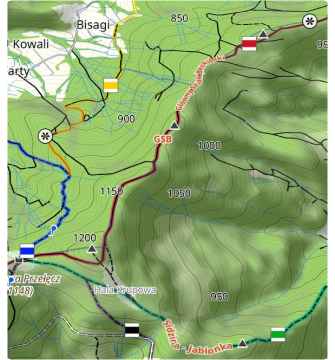
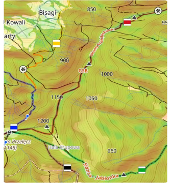
Contour lines and Terrain
Available for Android and iOS. Paid feature.
Contour lines and relief are our first integrated features for the app to customize and display relief information. These features are available for both Android and iOS versions of the OsmAnd app. Read about it in the Topography plugin article.
Elevation graphs
Available for Android and iOS. Free feature.
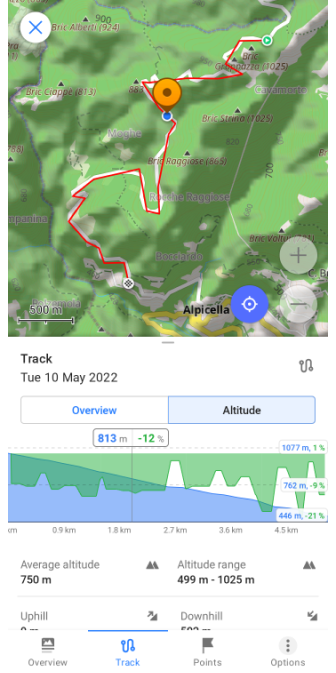
During the navigation route building you are provided with Altitude and Slope data in the form of a graph, and with the "Analyze on map" function you can find out additional, more detailed information about the route.
A detailed description of the graph you can find in the Altitude section of the Track Context Menu article.
OsmAnd Pro terrain features
Our team has added features for users of the Android and iOS versions of the app with an OsmAnd Pro subscription  :
:
- Elevation widget (Android),
- Online Elevation profile (Android),
- Heightmap 3D (Android and iOS),
- "Elevation: map center" widget (Android).
Elevation widget
Available for Android only.
The Elevation widget shows a graph with the elevation and slope of your navigation route and your current location on this graph with current altitude and slope. This is a paid feature for OsmAnd Pro subscribers.
Online Elevation profile
Available for Android only.
Online Elevation profile is our paid OsmAnd Pro subscription feature. It allows you to calculate elevation profile for each points on your GPX track. The feature only works in online mode.
3D Heightmap
Available for Android and iOS.
How to start testing 3D relief right now:
- Download and install OsmAnd 4.3+ for Android or iOS.
- Enable Plugin: _OsmAnd Development → Settings → Heightmap.
- Download Heightmap maps for your region in the Download map menu.
- Enjoy it.
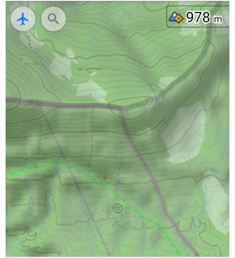
"Elevation: map center" widget
Available for Android.
The data of elevation is from Heightmap. How to switch on the widget:
- Download and install OsmAnd 4.3+ for Android.
- Enable Plugin: _OsmAnd Development → Settings → Heightmap.
- Download Heightmap maps for your region in the Download map menu.
- Switch on the widget: Menu → Configure screen → Left / Right panel → Altitude.
The altitude data on the map - between 70 degrees north latitude and 70 degrees south latitude - was obtained as a result of measurements carried out by the Shuttle Radar Topography Mission (SRTM). It used the Advanced Spaceborne Thermal Emission and Reflection Radiometer (ASTER), the primary imaging tool in NASA's Earth Observation System.
For full information see License:
DEM (DSM) data
- ALOS DEM: The original data used for this product have been supplied by JAXA’s AW3D.
-
MERIT DEM
- ArcticDEM: Porter, Claire; Morin, Paul; Howat, Ian; Noh, Myoung-Jon; Bates, Brian; Peterman, Kenneth; Keesey, Scott; Schlenk, Matthew; Gardiner, Judith; Tomko, Karen; Willis, Michael; Kelleher, Cole; Cloutier, Michael; Husby, Eric; Foga, Steven; Nakamura, Hitomi; Platson, Melisa; Wethington, Michael, Jr.; Williamson, Cathleen; Bauer, Gregory; Enos, Jeremy; Arnold, Galen; Kramer, William; Becker, Peter; Doshi, Abhijit; D’Souza, Cristelle; Cummens, Pat; Laurier, Fabien; Bojesen, Mikkel, 2018, “ArcticDEM”, Harvard Dataverse, V1
- SONNY's LiDAR DIGITAL TERRAIN MODELS (DTM) OF EUROPEAN COUNTRIES
Follow OsmAnd on Facebook, TikTok, Twitter, Reddit, and Instagram!
Join us at our groups of Telegram (OsmAnd News channel), (EN), (IT), (FR), (DE), (UA), (ES), (BR-PT), (PL), (AR), (TR).